We decided instead of take two days getting to Crater Lake National Park, we would do it in one long drive. According to the GPS the drive was supposed to take us 10 hours, crossing over 500 miles. As it turns out due to the parks campgrounds being full, and a poorly constructed road system in the park we drove for just under 12 hours. Finally stopping to camp about 20 miles outside the park. Bummer.
Day 39
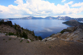
Not letting yesterday's long drive upset us, we decided on a casual day with a few small hikes, and perhaps some swimming in Crater Lake. Crater Lake is just as it sounds, a massive crater six miles across, and filled with water. It is the deepest lake in North America, and also one of the clearest lakes in the world, with visibility down to 400ft, though the lake itself is 2000ft at it's deepest point. The crater itself was formed when the mountain that used to stand in its place erupted. Consequently the eruption took place right around the time of Noah's flood. Hmm interesting. A smaller second eruption constructed a small island jutting 800ft out from the lake.
Due to the steep slick sides of the crater, there is only one trail down to access the lake. 1.1 miles down with 700ft of elevation loss to a boat dock where they do tours. Of course the tours are $40 a ticket. Needless to say, we passed on the tour. We did hike down the trail, and were greeted by the bluest, clearest water we had ever seen. Of course we promptly found the tallest cliff we could find along the water, and jumped! Over and over, until the ranger got fussy and yelled at us. Not that there were any signs saying no jumping. Oh well, we got some good 30ft jumps in.
After hiking back up we headed back over to the campground inside the park, with hopes of getting a campsite. Strangely Crater Lakes campgrounds are not run by the National Park service, instead by a private excursion company called Exterra. They would not allow any registration until close to 1:00pm, throwing a wrench into our afternoon activities. We did end up with a campsite, and decided to have some lunch to celebrate before heading back out to do some hiking.
After a delicious pizza lunch we hopped over to the trailhead for Mount Scott, the highest peak in the park. The view from the top was supposed to be spectacular. The hike was relatively easy, 1700ft of elevation gain in a 2.5 mile hike up a series of switchbacks. Upon arriving at the summit, we found the lookout station locked, which didn't stop us from climbing up onto the deck to get a look around. The views did not disappoint, we could see all the way to Mount Shasta to the south, and a perfect view of the lake to the north. Definitely a worthwhile hike.
MILEAGE:
Driving-
This trip: 551
Total: 5511
Walking-
This trip: 7
Total:206 (Woot 200 miles!)


No comments:
Post a Comment